Auburn and Opelika Rails-with-Trails Project
Tyler Hemby, Elizabeth Anderson, Azeem Ahmed, and Lauren Frazer
Student Report
SUST 5000 Senior Capstone in Sustainability
Minor in Sustainability Studies
Auburn University
24 April 2014
Purpose
In order to maximize the opportunities for sustainable transportation in the Auburn-Opelika area, and promote resident wellness through exercise and contact with the outdoors, our group proposes to build a bicycle trail from Auburn to Opelika. The trail will utilize the easement space for the existing railroad system, which is an active line currently owned by CSX. From this primary section of the trail, reaching from downtown Auburn to downtown Opelika, it will be able to branch out into other key areas of the community. Key areas that could be reached through additional trails include the Auburn University campus, grocery stores such as Kroger and Earthfare, and local shopping centers. The rail-with-trail could also be extended over time to stretch further down the railroad, reaching Loachapoka, Notasulga, and other nearby communities. This greater connectivity will allow more access to healthy food for those without personal vehicles, reducing the food deserts in the area. Ideally, the trail system will one day create a well-connected and safe bicycle network for residents of Auburn and Opelika.
We have begun to determine the feasibility of the creation of such a trail through researching similar case studies, liability, and costing of the trail. Meetings with representatives from the cities of Auburn and Opelika, and the distribution of surveys both have aided us in determining the public and municipal interest in the creation of this trail.
Goals
The creation of this trail will serve to decrease personal vehicle use, concurrently increasing the exercise and wellbeing of Auburn and Opelika residents. This, in turn, will lower greenhouse gas emissions and deter congestion of Opelika Road and surrounding areas. In addition, development of this green space will provide a safe recreational space and help revitalize the areas it passes through, while connecting these areas to food sources, decreases the prevalence of food deserts in the Auburn-Opelika area.
Our group anticipated the chance to influence the appropriate city and railroad authorities to undertake this project. We plan present our feasibility study for development of this area to these authorities, with the support of parties such as local businesses, residents living near the railroad, and community groups and organizations. We plan to hold these meetings to pitch our proposal prior to the completion of this project.
Rails-with-Trails
Much like its more famous cousin Rails-to-Trails, Rails-with-Trails projects involve the creation of biking and walking trails along railroad corridors. However, while Rails-to-Trails projects involve the conversion of out-of-use and defunct rail corridors into pedestrian and cycling trails, Rails-with-Trails projects actually place the trail alongside active rail lines for part of, or all of, their extent. Rails-with-Trails projects are growing in popularity with over 161 completed trails in 41 states. These trails vary widely in length, design, use, proximity to the tracks, type of rail service, and ownership (Rails-to-trails Conservancy 2000).
Route and Design
The proposed trail is to run from downtown Auburn to downtown Opelika, following the railroad – a distance of 6.6 miles. It is to use the existing easement space of the railway where possible. The trail is proposed to have one terminus at the intersection of the rail corridor with College Street in Auburn, and another terminus at the intersection of the rail corridor with South 8th Street in Opelika, as can be seen in Figure 1. In between these points the path will cross four major roads (Gay St, Dean Rd, University Blvd, and 9th St) which will necessitate the installation of automated crossing systems that connect with existing traffic light systems at each crossing. The path will also cross eight smaller roads that are not large enough to warrant a traffic light system, but will instead only need signage and possibly painted crossing marks on the road. In addition, the path will cross one creek which will make the installation of a bridge necessary, and will cross another rail line near the center of Opelika which will require the installation of an at-grade crossing system.

Figure 1: Proposed Path of Trail
As seen in Figure 2, the proposed trail is designed as a multi-use trail, allowing for the safety of both cyclists and pedestrians. The users are protected from the passing trains through both the setback distance and various forms of separation. The setback distance is highly variable based on the demands of the railroad owners, the speed of the trains passing, and the frequency of the trains. For this project, it should be determined as negotiations move forward with CSX. If additional separation is required, it commonly includes fencing, vegetation, or grade changes. In all cases, consideration should be given to the use of these lands as wildlife corridors, and barriers should not prevent the crossing of animals.

Figure 2: Plan View of Trail
The addition of maintenance roads along the railroad is another feature shown in Figure 2. These provide ease of maintenance for the railroad owners, providing an added incentive for them to allow the rail-with-trail to be built. The maintenance roads and trail are designed to be of pervious pavement for this project. The use of pervious pavement serves to aid in recharging the groundwater, as well as reducing stormwater runoff and pollution.
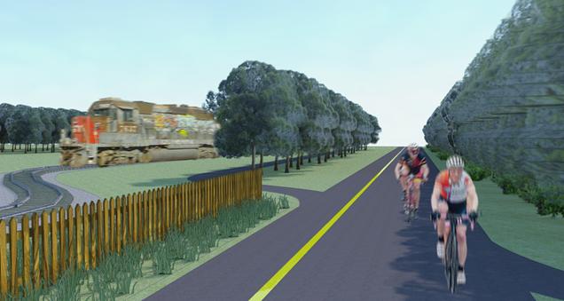
Figure 3: Rendering of Trail
Safety and Liability
The safety of trail users and the question of liability in the case of accident or injury are by far the most significant concerns raised by rail operators. In the twenty years covered by the study provided by the Rails-to-Trails Conservancy, only one fatality of a trail user has been reported. This is in stark contrast to the tens of thousands of deaths that have occurred to pedestrians in rail corridors as a whole across the country. This would seem to indicate that the presence of these trails actually reduces the number of deaths along rail lines significantly, as people are no longer tempted to utilize the corridor as trespassers in an unsafe manner (Rails-to-trails Conservancy, 2000). In addition, a study conducted by Jacobsen, Racioppi, and Rutter suggests that automobile traffic and the dangers associated with walking and biking in close proximity to it, severely discourages individuals from biking and walking (Jacobsen et al, 2009). This means that the creation of a safe alternative, such as our path, would encourage biking and walking to get around in the Auburn and Opelika area.
The two primary ways that trail creators ensure the safety of their trails is through the use of barriers and fences, and setbacks from the track itself. In 70% of the trails included in the Rails-to-trails Conservancy study, a barrier or fence was included along part or all of the trail. This is an easy way to ensure that users of the trails are not tempted to crossover onto the active rail lines. Another way that safety is dealt with is through the implementation of a setback from the tracks. Setbacks can range widely from as close as 2 feet to as far as more than 100 feet away from the tracks themselves, though most trails have setbacks that run between 11 and 30 feet. Setbacks can generally be smaller if a barrier of some kind is installed, but often requirements for these two features are set by an agreement with the rail companies (Rails-to-trails Conservancy, 2000).
In all 50 states, Alabama included, there is some form of what is known as a Recreational Use Statute. Alabama’s Recreational Use Statute states that “An owner, lessee or occupant of premises owes no duty of care to keep such premises safe for entry and use by others for hunting, fishing, trapping, camping, water sports, hiking, boating, sight-seeing, caving, climbing, rappelling or other recreational purposes” (Code of Alabama 35.15.1). This statute effectively clears the rail company of liability for users of our proposed trail, however in many previous rails-to-trails case rail companies have required some other transfer of liability away from themselves. This often comes in the form of either insurance taken out by the managers of the trail, or indemnification of the rail company (Rails-to-trails Conservancy, 2000).
Cost Estimate
The numbers and estimates utilized in the economic feasibility portion of our project stemmed from a case study provided to our class by Mr. Jeffrey Dumars, Campus Planner, Auburn University. The case study, a proposed plan for a state line to state line bikeway project in California, outlines costs for construction items, such as bridges, landscaping, and paving. Using this as a guideline for what to include in our own cost estimations, we were able to create an approximate projection of how much the proposed path would cost.
In order to decrease the environmental impact of the path we decided to use pervious pavement as our paving material rather than regular asphalt. We also decided that major road crossings would need an automated crossing system which would connect with traffic lights already in place at these intersections, but that at most only four roads along the proposed path met that criterion. The other crossings would only require signage on both the path and the road and painted guidelines across the intersection. In addition, we estimated the cost of placing a 3 to 4 foot high fence between the railroad and the bike path. This would help alleviate some safety concerns and allow for some beautification of the pathway. The last two major costs components of the project included a bridge, landscaping, and lighting along the path. There is an area in Opelika where the train does run over a bridge. The cost of this prefabricated bridge would vary but would be necessary for riders to utilize the length of the bike trail. Landscaping costs would include lighting of the area and any beautification alongside the trail such as plants, trees, benches and signage. Below is a table laying out our estimated cost calculations:
Table 1: Cost estimate
|
Construction Component |
Measurement |
Amount |
Cost |
Total Cost |
|
Temporary Erosion Control |
LF |
34,848 |
$ 10.00 |
$ 348,480.00 |
|
At-grade Crossing Control System |
EA |
4 |
$ 5,000.00 |
$ 20,000.00 |
|
Non-Automated Crossing |
EA |
6 |
$ 1,000.00 |
$ 8,000.00 |
|
Permeable Pavement Path |
LF |
34,848 |
$ 20.00 |
$ 696,960.00 |
|
At-Grade Rail Crossing System |
EA |
1 |
$ 80,000 |
$ 80,000 |
|
3 to 4 Foot Safety Fencing |
SQF |
34,848 |
$ 8.00 |
$ 278,784.00 |
|
20' L x 12' W Prefabricated Bridge |
EA |
1 |
$ 60,000.00 |
$ 60,000.00 |
|
Misc. Landscaping (Including lighting) |
|
|
|
$ 300,000.00 |
|
|
|
|
|
$ 1,792,224.00 |
After calculating these costs, with input from knowledgeable parties, we were able to project an estimated cost of $1,792,224.00. We believe that this is a very reasonable amount for the project, considering all of the necessary Rails with Trails components and benefits to the communities of Auburn and Opelika that would be provided through the trail’s creation. Furthermore, with the possibility of governmental and private organization grants and funding, the costs to the cities and taxpayers of Auburn and Opelika could be even lower.
Sustainability Rationale
Our Common Future, a report put out by the World Commission on Environment and Development in 1987, put forward one of the first and the most commonly cited definitions of the idea of sustainability and sustainable development stating that it is “development that meets the needs of the present without compromising the ability of future generations to meet their own needs” (World Commission on Environment and Development, 1987). The report goes on to elaborate that to meet this standard we must balance equally the needs of our society, the economy, and the environment. Our proposed plan to create a safe and accessible cycling and pedestrian path between the cities of Auburn and Opelika handily promotes the needs of all three.
This “rails-with-trails” path would greatly benefit the Auburn and Opelika community. Such a safe and easy way for people to walk and bike between and around the two cities would strengthen community bonds and person-to-person connections. In addition, the trail would promote personal health and the fitness of community residents by allowing people to utilize walking and biking as transportation alternatives to the automobile, and simply as a way to recreate safely. This is a point of great importance in our modern society as obesity and other health issues related to sedentary lifestyles become more and more prevalent (Higgins & Higgins, 2003). From a social justice perspective, this trail is also intended to help alleviate some issues of food insecurity for the lower-income individuals in both Auburn and Opelika—neither of which have healthy food options that are easily accessible without an automobile. Coveney and O’Dwyer (2009) demonstrate that safe and easy transportation networks, such as our trail, are more important to improving food accessibility than other factors.
Hand-in-hand with the benefits provided to the community by our path come the benefits provided to the local economy. As I mentioned before, the trail would strengthen community bonds, and, as a corollary, would also strengthen local businesses by providing consumers with increased access. Additionally, the creation of the biking and walking infrastructure would be a boon to local construction and related industries, and would promote bicycle tourism in the area, not to mention the fact that less expenditure on gasoline and car maintenance means more discretionary funds that could be used at local businesses (Flusche, 2012).
On top of the benefits provided to society and the local economy, the trail would have significant implications for both the local and global environment. The most prominent of which is the simple fact that if people are walking and biking instead of driving to many of their local destinations, less gasoline is burned and less CO2 and other greenhouse gases are being put into the atmosphere. Higgins and Higgins (2003) suggest that if all adults between the ages of 10 and 64 were to bike the recommended amount of cardiovascular exercise per day in place of driving, that that would lead to a decrease of 34.9% in domestic oil consumption. Furthermore, in the construction of our trail we plan to utilize sustainable materials and practices, such as pervious concrete, as much as is feasible.
In addition to the measures of sustainability offered up by the Brundtland Commission, the book Thriving Beyond Sustainability outlines the SPIRALS framework for assessing “thrivability”—a term which the book defines as going beyond sustainability, making the “shift from ‘less bad’ solutions to solutions that energize us and improve our quality of life through our connections with all life forms” (Edwards, 2010). The SPIRALS framework states that thrivable projects are Scalable, Place-making, Intergenerational, Resilient, Accessible, Life-affirming, and involve Self-care (Edwards, 2010). Our trail project is most certainly Scalable, as the Rails-to-trails Conservancy (2000) report details the specifics of 61 other similar successful projects across the country. It is also Place-making as it connects the communities of Auburn and Opelika and taps into their shared railroad heritage, and Intergenerational as members of the communities will be able to utilize it for many years to come. It is also socially Resilient as it can be used for recreation, transportation, or whatever other needs the community may desire, and ecologically Resilient, as it cuts down own car traffic, will be constructed with environmentally friendly materials, and involves little or no new clearing of land since it runs along the railroad right-of-way. More than anything this project meets the criteria of Accessibility, as it is designed to be freely utilized by all members of both communities whenever they desire. Finally, the project is Life-affirming for many of the same reasons that it is resilient, and very much involves Self-care, as it allows for, and promotes the health and mental benefits of physical activity.
Not only does our Auburn-Opelika rails-with-trails project meet the standard definitions of sustainability, but it goes beyond that to meet the requirements of a thrivable project which encourages “the human spirit to prosper and flourish” (Edwards, 2010).
Methodology
Development of the bike highway followed a multistep process which included the investigation of existing rails-with-trails case studies, the development of a route and relevant safety infrastructure, a survey of local bikers, and meetings with stakeholders such as the cities of Auburn and Opelika as well as CSX which owns the railroad tracks.
Step 1: Case studies and Legal restrictions: the team investigated case studies of similar rails with trails programs to highlight their success and identify best practices. This phase also included researching easement laws and contacting real estate and development experts for relevant information. A list of safety features for a rails-with-trails project was also developed.
Step 2: Route development: The second step included the development of a route from the North College Street rail intersection in Auburn to South 8th Street in downtown Opelika using GIS data. A cross-sectional model of the trail was also developed using CAD, along with renderings of what the trail might look like.
Step 3 - Cost Assessment: A brief cost assessment and feasibility study were conducted. The approximate cost of constructing the bike highway was determined from existing Rails-with-Trails projects, and a proposed cycling trail from California. The cost-per-mile included labor, material, landscaping and other miscellaneous expenses.
Step 4 - Bike Survey: The team developed a survey to gauge local biker interest in the bike highway. Bikers at the annual Auburn Bike Bash on April 12th, 2014 were asked to complete the survey, which asked bikers to rate their biking experiences, the local biking infrastructure and their likeliness to utilize the proposed bike highway.
Step 5 – Meet with Stakeholders: This step included meeting with various stakeholders to develop buy-in for the project. The most critical of these was with the cities of Auburn and Opelika to convince city managers of the safety, environmental, economic and social benefits of such a program. City officials expressed great interest in the project and indicated that they are working to better integrate the city’s biking infrastructure. Two city engineers stated the cost estimate underestimated the cost of the project, noting that costs associated with maintenance of the bike path were not included. We made this presentation on April 14th, 2014.
Step 6 – Presentation: The final models, project summary and cost analysis was presented at the SUST 5000 capstone class at Auburn University.
Survey Results
Forty-eight bikers were surveyed at the 2014 Auburn Bike Bash. While the survey only included bikers, the results were strongly in favor of the bike highway. 78% of those surveyed were permanent residents of Auburn (as compared to transitory students), and a similar percentage were over the age of 25. Over 50% of respondents claimed to bike at least once per week and 95% agreed that they would bike even more of the cities provided better biking infrastructure. 41 of the 48 bikers said they would utilize a trail between Auburn and Opelika with only 7 objecting to a placing the trail along an active railroad.
Evaluation
The primary means of evaluation for our project came from our meeting with both Auburn and Opelika officials. This allowed us to present our findings to a knowledgeable group of people who could provide feedback on our research and feasibility report. Bike clubs and local commuters were also surveyed for their opinions on bike safety and interest in using a bike highway. Using the survey gave us even more relevant feedback from the perspective of residents and bike riders. This survey was distributed amongst other biking organizations in the area to be used in future discussions. The results from our meeting and from the survey provided valuable feedback to our project and allowed us to further evaluate the feasibility of the rail-with-trials concept in Auburn.
Project Products, Artifacts, and Materials
The final product of this project is a comprehensive report and analysis of the benefits, process, and feasibility of the creation of a ‘rail-with-trail’ bike path from Opelika to Auburn. This report contains information about other successful rails-with-trails projects, the rationale for sustainability in the project, and the different phases that the project would go through before its final completion.
In addition, we have prepared two presentations – one scholarly, to be used in our coursework, and the other more persuasive, to be used in ‘selling’ our idea to the stakeholders. To be shown concurrently with the presentations we have prepared a map, a digital rendering, and a plan view of a section of the proposed trail.
Using this presentation we met with representatives from the cities of both Auburn and Opelika, including Justin Steinmann, Auburn’s principal planner, Tyler Caldwell, another planner for the city of Auburn, Scott Parker, the city engineer of Opelika, and Shirley Lazenby, the head of the Opelika Bicycle Advisory Committee. All of the representatives present were very interested in the concept we pitched, and seemed genuinely interested in looking into the prospect of a path like the one we designed for the Auburn-Opelika area.
Future Development and Next Steps
With the completion of all surveys, models and stakeholder meetings the Auburn-Opelika Rails with Trails program will need to be formally presented to CSX officials. Additional meetings will be needed with city engineers and lawyers. A community-led task force will need to be formed to oversee implementation. Once CSX approves the development of a rails with trails, local bike clubs and residents along the train tracks will need to be formally surveyed to ensure that any development address their needs and concerns. Finally, the team will meet with local businesses along the train tracks to garner support and establish guidelines to help them accommodate additional bike customers (such as bike racks and service points).
Conclusion
Overall, this project was extremely interesting and fun to research. We believe that the construction of a rails-with-trails path in Auburn will encourage sustainability, as well as promote community. Rails-with-trails throughout the country have promoted safer bike transit and resident health. A rails-with-trails project between Auburn and Opelika would provide resources for food-insecure residents, support local businesses, and serve as a means to encourage and promote sustainability. We have come to this conclusion through hours of research, meetings with relevant contacts, and analysis of the current rail system in Auburn and Opelika. As we are leaving Auburn, this project now rests in the hands of bike advocacy groups in the community as well as the cities of Auburn and Opelika. Further discussion with CSX is needed as well as further cost analysis and environmental studies. We would be very pleased to see this trail come to fruition and we truly hope that is a piece of bike infrastructure that will be considered in the future.
Project Resources
Primary Contacts:
Alabama Department of Transportation
Transportation Director of Alabama
John Cooper
Alabama Department of Transportation
P.O. Box 303050
Montgomery, Alabama 36130-3050
CSX Railroads
TellCSX System
877-835-5279
Auburn
Mayor Bill Ham, Jr.
1846 Hayden Avenue
Auburn, AL 36830
334.501.7259
Opelika
Mayor Gary Fuller
gfuller@ci.opelika.al.us
334.705.5151
Potential Supporters:
Auburn-Opelika Tourism Bureau
John Wild
President
johnwild@aotourism.com
334.887.8747
Auburn Bicycle Committee
Brandy Ezelle
Auburn Public Works Representative
bezelle@auburnalabama.org
East Alabama Cycling Club
Mike Hogan
President
mk1hgn@yahoo.com
300 Opelika Rd #2306
Auburn, AL 36831
Opelika Main Street
info@opelikamainst.org
334.745.0466
Food Bank of East Alabama
334.821.9006
Earthfare
334.821.0211
Dayspring Nature Shoppe
|
|
334.821.1965
|
The Bike Shop 334.821.6066 |
James Bros Bikes
334.821.0555
Media:
The Plainsman
news@theplainsman.com
Auburn-Opelika News
(334) 749-6271
Works Cited
Code of Alabama 35.15.1
Coveney, J., & O'Dwyer, L. A. (2009). Effects of mobility and location on food access. Health & Place, 15, 45-55.
Edwards, Andrés. (2010). Thriving beyond sustainability: Pathways to a resilient society. Gabriola Island, BC: New Society Publishers.
Flusche, D. (2012). Bicycling means business: the economic benefits of bicycle infrastructure. Retrieved February 10, 2014 from <http://www.advocacyadvance.org/site_images/content/Final_Econ_Update%28small%29.pdf>
Higgins, P. A. T., & Higgins, M. (2005). A healthy reduction in oil consumption and carbon emissions. Energy Policy, 33, 1-4.
Jacobsen, P. L., Racioppi, F., & Rutter, H. (2009). Who owns the roads? How motorised traffic discourages walking and bicycling. Injury Prevention, 15, 369-373.
Rails-to-trails Conservancy. (2000). Rails-with-trails: Design, management, and operating characteristics of 61 trails along active railroads. Retrieved from <http://www.railstotrails.org/resources/documents/resource_docs/Rails-with-Trails%20Report%20reprint_1-06_lr.pdf>
World Commission on Environment and Development. (1987). Our common future. Oxford: Oxford University Press.